
Thanks to its long history of oil and gas exploration, the geology of Western Pennsylvania resembles a huge block of Swiss cheese.
From the industry’s beginnings in 1859, when Edwin Drake struck oil less than 70 feet beneath the surface just south of Titusville, to the modern-day fracking boom that launched in 2004, hundreds of thousands of wells have been drilled into the landscape—adding to a labyrinth of shafts and tunnels from the region’s coal mines.
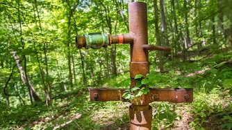
Many of these wells have long since been abandoned. Their operators may have gone out of business, if they are even known. Some old wells are still obvious from rusting wellheads and pipes. But in many cases, there’s little sign of them at the surface.
These wells are hidden in forests, shopping centers, even the Pittsburgh Botanic Garden. Others lie beneath the terminal and runways of the Pittsburgh International Airport. There could even be a hidden well in your backyard or beneath your home.

And while many of these wells pose little hazard beyond tripping over a protruding pipe, some may be leaking explosive methane, toxic carbon monoxide or carcinogens like benzene. Oil and gas wells can create air and water pollution. Exercise great care if you think a well may be nearby.
The state’s Department of Environmental Protection does provide an oil and gas well mapping tool. But it can be slow and difficult to use, especially if you’re not an expert.

Inside Climate News and the Pittsburgh Post-Gazette teamed up to develop a streamlined and responsive tool that would help state residents identify the locations of wells near their homes, schools, workplaces and parks, grouping them into a small number of meaningful categories and providing easy-to-digest information about each well.
We have simplified the state’s system for classifying wells into four categories:
Active/Other. These are mostly wells that are still producing oil or gas. However, the state’s active category includes wells that have no other status description, which means that some disused wells may be mistakenly included. We have also included a small number of wells with “regulatory inactive status,” which allows an operator to shut down production for up to five years without having to seal a well.
Plugged wells are recorded as sealed. Most were plugged by contractors hired by their former operators, but some were sealed by the state. Plugging may fail because materials like metal pipe and cement deteriorate over time, so some of these wells may still leak gases.
Abandoned/Orphaned includes abandoned wells, which have been out of production for more than 12 months. Orphaned wells are abandoned wells for which no responsible operator or owner exists.
Historical. In addition to its oil and gas wells inventory, which is regularly updated, the Department of Environmental Protection is in the process of digitizing historical maps showing older wells. These maps are not comprehensive—so far they only cover the southwest of the state—and have largely not been verified by modern inspections. Treat this information with extra caution.
We have excluded wells that appear in the state’s data as proposed but never actually drilled.
Explore the map below. You can type an address and hit the search button or accept suggestions. On a search, the map will zoom to the location and display information about the well, including the distance from the searched location. You can then click on other wells in the map view to see information for them.
If photos taken during government inspections are available, you can click on the “See photos” button in the information window to view them.
We used the interactive map to locate relatively new suburban neighborhoods built on top of hundreds of old oil wells in Allegheny County. This brought us to South Fayette Township and, specifically, to the Berkshires neighborhood, where homeowner after homeowner told us they weren’t aware of the wells from historical maps marked by purple dots in the interactive tool.
What the Data Can and Can’t Tell You
The Department of Environmental Protection is responsible for the accuracy of the data. If you have concerns about any wells shown on the map, contact the agency directly through this form or by calling the agency’s oil and gas office in your area.
The agency warns that an individual well may appear in both historical maps and its actively maintained inventory. Wells may also be duplicated, possibly with slightly different locations, across the two digitized historical map collections used for our Historical category.
Wells may be misclassified in the state data. For example, Jane McGill #1, an old well on the property of the Pittsburgh Botanic Garden, was at the time of publication listed as “active” by the Department of Environmental Protection, but it is actually an abandoned well.
We have only been able to include wells mapped by the agency. Many older wells—possibly several hundred thousand—are missing from the records. In addition, we were unable to map more than 29,000 wells for which the Department of Environmental Protection’s inventory gave no coordinates. About half of these are Plugged wells, almost 6,000 fall into our Abandoned/Orphaned category, the remainder are Active/Other.
So even if our map shows no nearby wells, they may still be present. Signs may include dead vegetation, bubbling in water, rusted metal equipment, unexplained sinkholes and unidentified petroleum smells.
When reporting concerns about wells, you will need GPS coordinates for the well. The more information you can share about environmental or safety risks, the more your report will be prioritized. Wells that the state deems “direct threats” to homes, schools or public spaces can be plugged immediately under emergency contracts.
If you’d like to test your well water, Penn State University offers testing for oil and gas drilling pollution.
Our map was built using free and open-source software. You can review the technical details, code and full methods in this GitHub repository.
Send Us Your Tips
Have a tip for us about abandoned and orphaned oil and gas wells in Pennsylvania? Tell us at tips@insideclimatenews.org.



Comments
Welcome to Post-Gazette subscriber-only commenting community. Please review our community guidelines.