


American school children are commonly taught (or used to be) about Pittsburgh's three rivers, the Allegheny, the Monongahela, and the Ohio. The confluence of the three rivers is Pittsburgh's reason for being more than a frontier outpost. The Allegheny and the Monongahela were not readily navigable, and approach their juncture from the north and south rather than from the more populous east; but the so-called Forks of the Ohio marked the head of navigation on that great river, and thus functioned as a gateway to the American west.
Less well known is the topographical setting through which the rivers course. Pittsburgh is built on a portion of the Appalachian Plateau that extends westward from the Allegheny Front, a high escarpment that slices diagonally across Pennsylvania and assures that the western part of the state is substantially higher than the east. Elevations in the Pittsburgh region range from 710 feet above sea level where the rivers meet, to 1,200 to 1,300 feet at the highest points. There are three primary topographical conditions from datum line to datum line: floodplains and bottomlands in the river valleys, uplands midway between rivers and hilltops, and high land at the prevailing level of the plateau. Slopes tie it all together.
Consequently, the city of Pittsburgh lies unevenly upon unruly land. Communities and neighborhoods are variously defined by hills and demarcated by hollows. Buildings may be two stories on one side and four or five on another. There are a great number and variety of contrivances for scaling, connecting, and otherwise negotiating the terrain, ranging from bridges to tunnels to inclined planes and public steps. Landforms shape topographical space and the city occupies that space with tenacity and verve.
Pittsburgh's topographical space provides the context for everyday experience. Bruce Lindsey relates how the rivers and the hills "are always present in your mind as behind you, or on your right, or below." What is in the mind is also in the eye. In Pittsburgh, says Patrick Horsbrugh, "the topographic form and the consequences thereof, are inescapable. They condition every action, they confine every vista, they expose every prospect." Walter Kidney observes that in Pittsburgh, "more than in almost any other city, the third dimension is important in the look of things. You cannot go far before you find yourself looking up the side of a hill, or forward into empty space." Pittsburgh, says photographer Clyde Hare, "stands up and looks you in the face." And we look back.
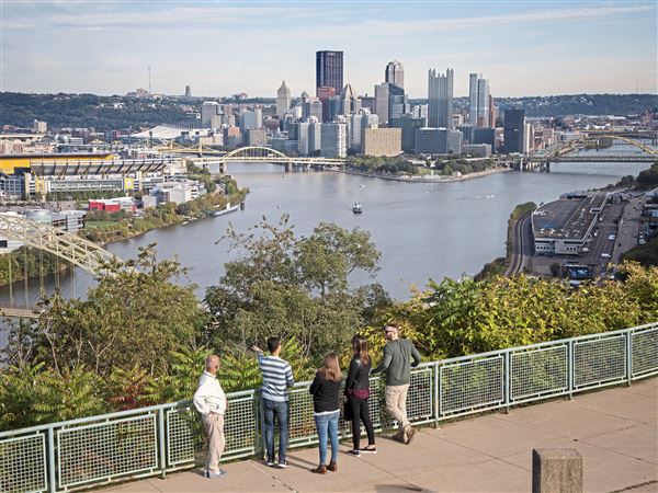
Perceiving the topographical city entails simultaneous perception of the land and the city. A classic bird's-eye view of Pittsburgh depicts urban development and the underlying terrain with equal weight. Foliage acts as both pictorial frame and pastoral setting. Figures in the foreground are a familiar presence from the tradition of landscape painting; they are denizens of a romantic scene. Yet they are also inhabitants of a bustling city and spectators actively taking in the view. They see an expansive panorama that appears to encompass the curvature of the earth. In fact, the view focuses on one discrete space in the topographical city.
Pittsburgh's topographical and pictorial space is organized into what William Rees Morrish calls "terrestrial rooms." Morrish contends that our concept of the room, and of human occupation generally, is derived from spaces that are enclosed by surrounding landforms. For "within the . . . uncultivated landscape, the landforms contain resources, rooms to contain the heterogeneity of urban growth."
Within the local Appalachian Plateau, "all the hills and stream divides rise to about the same elevation, the sky line as viewed from a hilltop appearing like that of a flat plain." Thus the hills are not really hills; it's the valleys and the hollows that are real, voids in the solid of the overarching plateau. Pittsburgh, notes Horsbrugh, is "a city of spatial volumes, mostly enclosed." When James Parton, writing in the Atlantic Monthly in 1868, famously called industrialized Pittsburgh "Hell with the lid taken off," his prose was shaped not only by the prevailing fire and smoke of the city's ironworks, but also by his specific viewpoint, looking "over into" a valley that he perceived as an abyss. Elsewhere in his essay, Parton writes of the "deep chasm in which Pittsburgh lies," as "at the bottom of an excavation." In The Mysteries of Pittsburgh, contemporary novelist Michael Chabon describes the so-called lost neighborhood at the bottom of Junction Hollow, "the mysterious couple of streets and row or two of houses-a diorama, which one sees only from above . . . at the bottom of Pittsburgh."
The topographical city encompasses many terrestrial rooms that contain the heterogeneity of urban growth. They are omnium-gatherums full of buildings, industrial infrastructures, and engineered landscapes. Yet they are more than collections of random objects; for Pittsburgh's urban growth responds to the conditions of its topographical space. Frederick Law Olmsted Jr. praised "the bold picturesqueness of the [Pittsburgh] landscape --the deep ravines, the lofty hills, the precipitous declivities, the plunging prospects from hilltops into river valleys." At the same time, he perceived "a similar quality of forcefulness, activity, and bold irregular adaptation of means to ends" in the "dominant and impressive works of man in the city -- the steel works, the bridges and viaducts, the jagged skyline of office buildings." This study singles out three terrestrial rooms that are at once essential to any understanding of Pittsburgh, singular in their scope and qualities, and representative of the spaces and visual experiences of the topographical city.
Pittsburgh's greatest room is the so-called Golden Triangle, the city's point of origin and downtown core. The Golden Triangle lies within the basin at the confluence of the three rivers, one of America's great natural settings. Hemmed in by land and water, the Golden Triangle is densely concentrated and has been rebuilt a number of times over. It is a place of multiple eras and multiple visions and varieties of topographical response. Because of the terrain, downtown Pittsburgh is the "most 'down' of downtowns in the country," its ground plane deeply recessed below the surrounding hills. At the same time, its urban form reaches for the sky. The Golden Triangle is replete with vantage points and focal points composing views for the spectator, and its visual appearance is a key part of the city's identity.
Some ten miles east of the Golden Triangle, Turtle Creek empties into the Monongahela River at the mouth of the Turtle Creek Valley. The lower end of the valley is a room that is more like a passage, yet it holds a quintessential industrial landscape of waterways and railroads, factories and machines, and a great bridge. This landscape was largely realized in a discrete period of time (1877-1932), the product of powerful forces and a topographical response that was equal parts accommodation and exploitation. Here topography and technology forge a fantastic scene that evokes the technological sublime, brings a new scale and drama to the landscape, and plays as cinema for the spectator.
Between the Golden Triangle and the Turtle Creek Valley, Junction Hollow and Panther Hollow penetrate inland from the Monongahela River and issue in an upland ringed by higher ground. Here, within the rich urban fabric of Pittsburgh's Oakland district, is one of the great, albeit little known and not fully realized, sites of American architecture, landscape, and urbanism. The historical campus of Carnegie Mellon University (once known as Carnegie Tech) is the progeny of Thomas Jefferson's University of Virginia and the City Beautiful Movement. Yet it is also a distinctive vision and topographical response, sprung from the mind and hand of architect Henry Hornbostel. Though seemingly complete in itself, it broadly engages, and is contingent upon, the larger landscape, including two successive campuses of the University of Pittsburgh. Together, these elements compose a complex vista for the spectator.
First Published: December 5, 2006, 5:00 a.m.