
The first signs of trouble came along the riverfront.
Rising water spilled onto the Mon Wharf and crept toward Downtown Pittsburgh. Then floodwaters submerged businesses and cut off power and phone lines in the streets of the Golden Triangle.
By the morning of March 18, 1936, it was clear the city was facing the worst flood in its history.
After days of heavy rain and melting snow had poured into the region’s waterways, the Ohio River crested at a level that Pittsburgh had never seen: 46 feet, more than 20 feet above flood stage. At least 62 people died. Another 500 were injured. More than 100,000 were left without homes.
“As far as we have a written record, which does go back pretty far, ‘36 is the mother of all floods,” said Mike Bilder, a Montgomery County-based disaster historian and author.
The St. Patrick’s Day flood — 90 years ago this week — remains one of the defining events in Pittsburgh’s history, still factoring into decisions made today.
Read More
It shaped the region’s infrastructure, leading to construction of several dams, reservoirs and levees designed for flood mitigation. It pushed advances in weather forecasting and communication.
And it forced the Pittsburgh region to rethink how it coexists with its rivers — how it would fare if a disastrous combination of events like that struck again.
“It’s a reminder to all of us to be prepared,” said Andy Masich, president and CEO of the Heinz History Center. “We can’t count on flood control and dams to keep us safe all the time.”

‘A slow-motion disaster’
Pittsburgh had a glimpse of what could be coming.
New York, Connecticut and other parts of the Northeast had been grappling with severe flooding in the late winter of 1936.
As early as March 12, ice jams covered the Hudson River in eastern New York and rapidly began to melt. Combined with heavy rain, the river swelled to a high of 29½ feet in Troy, N.Y. , 8 feet above flood level, and 17.9 feet in Albany, nearly 7 feet above flood level, according to the National Weather Service office in Albany.
“It was kind of a slow-motion disaster at first,” Mr. Masich said. “I think people just didn’t believe that it could be as bad as it was.”
Like many cities in the Mid-Atlantic and Northeast that winter, Pittsburgh had been crushed by consistent snow and rain.

A snowstorm hit weeks before, and precipitation lingered for days, bringing about 3 inches of rain to the city in the three days surrounding St. Patrick’s Day, according to Alicia Miller, hydrologist at the National Weather Service’s office in Moon.
Meteorologists nearly a century ago relied on on-the-ground observations, weather balloons and handwritten data plots to track river levels. Ms. Miller suspected the earliest that forecasters could have given notice about what was to come was two to three days.
Even that didn’t come without challenges.
“[River observers] would use either phone or telegraph,” said Shannon Hefferan, lead meteorologist at NWS Pittsburgh. “But then some of the communication was cut off because the town was cut off, the railroads were cut off.”
As floodwaters rose in the early hours of March 18, the magnitude of the devastation came into focus.
Johnstown, where residents remained haunted by the failure of the South Fork Dam 47 years earlier, killing more than 2,200 people, was among the hardest hit.
The Conemaugh River rose to 39 feet during the 1936 event — more than 10 feet above flood stage. Floodwaters destroyed 77 buildings, severely damaged thousands of others, and killed about two dozen people, according to the Johnstown Flood Museum.

In and around Pittsburgh, people fled their homes and climbed up poles as water filled the streets, isolating them completely.
Railroad tracks were undercut and made unusable.
Power plants were inundated, cutting off the electric grid that powered the city.
The city hadn’t seen flooding that severe since the Great Flood of March 1907, when heavy rain and snowmelt pushed the Ohio River crest to 38.5 feet, according to the National Weather Service.
“Families were in the dark, literally and figuratively, trying to find out about their loved ones,” Mr. Masich said.
Patricia Taylor Williams, 65, told the Post-Gazette that her mother was nearly 7 years old when floodwaters swallowed the first floor of her family’s rowhouse in Pittsburgh’s West End.
As Thurley Hall Taylor’s two older brothers worked quickly to move furniture to the second floor, she was taken out of the area by a rowboat.
To Ms. Williams’ knowledge, the family never returned to the house, and the event left a mark her mother couldn’t shake.
“She would never go in a rowboat or canoe again,” Ms. Williams said.

What changed after 1936
In the aftermath of the flood, government officials made sweeping improvements to both communication and flood mitigation.
Meteorologists at the NWS today rely on a vast network of forecasting tools to analyze and communicate incoming weather events, such as GPS satellites, sensors at airports and rain and river gauges, Ms. Miller said.
And like in 1936, on-the-ground observers feed the team at the NWS office in Moon daily measurements of rain, snowfall and temperatures.
That data is entered into computer models, which forecasters run multiple times to get the most accurate information. They can also compare data with offices in neighboring regions.
As forecasters track storm patterns, they interact closely with the Allegheny County Department of Emergency Services and the City of Pittsburgh to ensure proactive messaging is sent out to the community.
“Obviously, the closer you get to the event, the more accurate we’re going to be,” Ms. Miller said. “But for some events, we can give almost a week’s notice.”
“It’s a reminder to all of us to be prepared. We can’t count on flood control and dams to keep us safe all the time.”
Andy Masich, president and CEO of the Heinz History Center
There were also massive changes to the region’s infrastructure after Congress passed the Flood Control Act months after the 1936 flood. It authorized the U.S. Army Corps of Engineers to construct dams and reservoirs.
One of the largest — and most controversial — flood-control projects was the building of the Kinzua Dam in Warren, Warren County. Its construction, completed in 1965, created the Allegheny Reservoir but flooded thousands of acres of Seneca Nation land, displacing hundreds of residents in the process.
“It changed their lives in a very long-lasting way,” Mr. Masich said. “I think we should remember them as we enjoy the power and the security that we enjoy today. Just know that it came at a cost.”
The Army Corps’ Pittsburgh District also completed several other flood-control projects in the 20th century.
The Tygart Dam and Lake in Fairmont, W.Va., which feeds the Tygart Valley River that eventually becomes the Monongahela River south of Morgantown, was built about two years after the 1936 flood.
The Crooked Creek Dam in Armstrong County and Tionesta Dam in Forest County were built in 1940, creating reservoirs that hold back floodwater during storms before gradually releasing it into the Allegheny River.

At least seven more reservoirs were built in the region between 1941 and 1970, according to an Army Corps report stored at the NWS office in Moon.
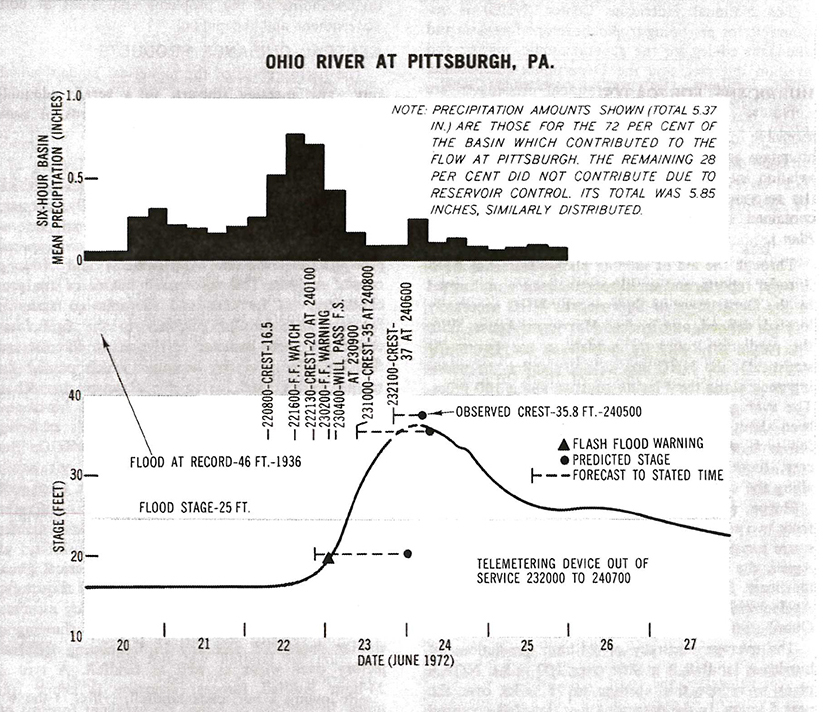
That system of reservoirs was pertinent for Pittsburgh residents in June 1972.
In a span of three days, Tropical Storm Agnes stalled over Pennsylvania, dumping between 10 and 18 inches of rain over the mountainous areas of the state and western New York., according to a report from the Susquehanna River Basin Commission.
Rivers and streams across the region overflowed. In Pittsburgh, the peak of the flood reached 35.8 feet on the Ohio River, according to historical records.

“Agnes really tested the reservoirs that were in place,” Ms. Miller said. “The Tygart reservoir was full. It went as high as it could go from that event; it really didn’t have much more it could hold back.”
Without the reservoirs, the crest of that flooding would have surpassed that of the 1936 flood, she said.
The region’s flood-control projects in the decades since the first dam was built in 1938 have helped avert more than $14 billion in flood damage, according to Army Corps estimates.
In a more recent event, reservoirs held back an estimated 6 feet of flooding from reaching the Point of Pittsburgh after back-to-back high-water events in April 2024. The Ohio River peaked at a little more than 28 feet, and towns all across the region were inundated.
“So I guess if the question is, could it happen again? Could we hit 46 feet again? We have had rainfall amounts that have potentially allowed for that to happen, but the reservoirs have saved us from that actually occurring,” Ms. Miller added.

Putting Pittsburgh to the test
Even with modern forecasting tools and the vast network of flood-mitigation projects, Pittsburgh isn’t entirely out of the woods.
The same weather ingredients that fueled the 1936 disaster — heavy rainfall on top of melting snow — can and almost certainly will occur, Ms. Miller said.
And there are still many smaller waterways not protected by major flood-control projects.
One example is Chartiers Creek, which extends nearly 50 miles from Washington County to the Ohio River and through flood-prone towns such as Bridgeville and Carnegie.
The creek has experienced frequent, systemic flooding in recent decades that has increased safety risks for communities alongside it.
The Army Corps has said it has plans to conduct a feasibility study to “evaluate possible flood-control management solutions and alternatives to reduce risk for the more than 250,000 residents living within the watershed.”
A closer look at the region’s flood control projects is critical as the earth continues to warm, increasing the frequency of high-intensity rain. The hourly rainfall intensity in Pittsburgh increased by 28% between 1970 and 2024, according to researchers at Climate Central, a nonprofit based out of Princeton, N.J..
“The biggest thing to take away is that we are more likely to see bigger rain events, heavier rain events, more intense rain events that will put out area to the test,” Ms. Miller said.
And there’s only so much government agencies and communities can do to prepare.
“We have the gold standard of weather forecasting agencies, but even with what we are able to do today, you’d be surprised about how unpredictable ice jam flooding and snow melt flooding still is,” said Mr. Bilder, the disaster historian who soon will publish books about the 1936 flood and Hurricane Agnes. “There are still things that science is trying to work out.”

Last June, residents near Wheeling and Fairmont, W.Va., had little time to prepare as flash floods struck. The regions saw up to 5 inches of rain in a matter of hours, and nine people were killed in the Wheeling area in the worst mass casualty event in Ohio County, W.Va., history.
For those who have properties near rivers and streams, Ms. Miller said, it’s important to maintain storm and sewage drain systems equipped to handle intense rainfall.
Experts also advise residents to develop their own disaster plans.
Set up rallying points for family members to meet. Stock up on nonperishable food and supplies. Keep electronic devices charged as long as possible to maintain contact and stay up to date.
“We are fortunate to be hyperconnected nowadays, so take these warnings seriously when you hear either from the government or from the meteorologists that make us aware of these things,” Mr. Masich said.
Reminders of the 1936 flood remain in Downtown Pittsburgh, with plaques still seen on some structures that show just how high the water climbed.
“Those markers that we see on Downtown buildings are tangible reminders of, hey, don’t be too complacent,” Mr. Masich said. “Mother Nature is still holding some cards.”





Comments
Welcome to Post-Gazette subscriber-only commenting community. Please review our community guidelines.