
Much of Western Pennsylvania is under a flood watch as another round of storms is expected to dump more rain on already saturated ground Thursday afternoon and possibly into the evening, according to the National Weather Service.
"In a general sense, around the Pittsburgh area, we could see anywhere from a ½ inch to ¾ of an inch of rain," said Chris Leonardi, a meteorologist at the NWS in Moon. "But locally, depending on how the band moves, some areas could see an inch to 1½ inches of rain."
Thursday's storm is being fueled by a lingering front to our north with cooler air above the Pittsburgh region and air to our south that's "humid and juicy," Mr. Leonardi said.
The brunt of the rain is expected between 11 a.m. and 3 p.m.
Forecasters are expecting that front to move on by Thursday night, but the threat of storms will continue until around 10 or 11 p.m.
"Our biggest concern at this point is the potential for flash flooding," said Mr. Leonardi. "Urban areas are always a concern, because it doesn't take much to flood there. But we'll be looking at the smaller streams."
Read More
Mr. Leonardi said the rainfall amounts haven't had a major impact on the rivers yet. At 6 a.m., the Ohio River near Point State Park was measured at 16.8 feet. At 18 feet, the Mon Wharf begins to flood. Mr. Leonardi said the water there is expected to crest at 18.4 feet by early Saturday.
In addition to more rain, Thursday's storm could also produce gusty winds, but Mr. Leonardi said he doesn't expect the winds to be severe.
A low pressure system moving into the region may bring some relief, Mr. Leonard said.
"It will kick the front through, so we'll get a break," he said. "We may see some rain early Friday, but most of Friday and Friday night is looking dry."
The break will be short-lived.
"Another front that's coming through this weekend will bring rain, so we have to keep a close eye on it," Mr. Leonardi said. "With the ground being so saturated, the potential for flash flooding is a continued threat."
Since late Monday, Mr. Leonardi said, storms have dumped up to 5 inches of rain in some areas.
"The highest amounts were in a band that basically stretched into southern Indiana County through southern Armstrong and southern Butler and into Beaver [counties]," he said.
Because of the scattered nature of Thursday's storms, Mr. Leonardi said it was tough to predict where the highest rainfall amounts would occur.
"Unfortunately, those areas will see some rain today," he said. "It's going to be scattered, but anything there has potential to cause flooding."
Water levels at Connoquenessing Creek in Zelienople of Butler decreased from 15 feet to just under 10 feet by Thursday morning, according to the National Weather Service. Several homes and businesses suffered intense flooding following Tuesday's storms. Flood levels at this creek begin at 10 feet.
As of 8:30 a.m., 846 West Penn Power customers remained out of service due to the storms — 173 in Allegheny County; 171 in Armstrong County and 295 in Westmoreland County. The remainder were scattered throughout the service area.
West Penn Power spokesman Todd Meyers said that from 4 p.m. Tuesday until Thursday morning, a total of nearly 20,000 West Penn Power customers were impacted by the storms, with power to more than 19,000 restored.
Less than 50 residents were without power in Butler, including Forward, Jackson and Zelienople. Some Butler areas experienced intense flooding beginning Tuesday evening and into Wednesday following storms.
About 200 miles east of Pittsburgh, the York area also was under a flood watch and had some of the highest power outages of First Energy customers due to storms. More than 16,000 customers were without power Wednesday evening, Mr. Meyers said. Roughly 4,300 York customers were still out of service as of Thursday morning.
Mr. Leonardi emphasized that motorists use caution.
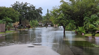
"Turn around if you see a flooded roadway," he said.
PennDOT said several area roads remained closed Thursday morning. Here is a list:
______________
ALLEGHENY COUNTY
● Route 1031 (Lardintown Road) from Route 908 to Butler County in Fawn Township closed due to flooding.
● Route 1034 (Bull Creek Road) from Ridge Road to Howes Run Road in Fawn Township closed due to flooding.
● Southbound Route 19 lane restriction near Cumberland Road in McCandless due to a clogged inlet.
● Route 8 lane restriction from Craighead Road to Mt. Royal Boulevard in Hampton due to a clogged inlet.
● Route 2017 (Douglas Run Road) in Elizabeth Township closed due to downed tree and live wires.
______________
BEAVER COUNTY
● Route 588 from Hartzell School Road to Pine Run Road in Marion Township closed due to flooding.
● Route 1019 (Brush Creek Road) from Route 68 to Route 588 in Marion and New Sewickley townships. closed due to flooding.
● Route 1008 (Soap Run Road) in Franklin Township closed due to flooding.
● Route 2006 (Lovi Road) in New Sewickley Township closed due to slide.
● Route 68 lane restrictions in Midland Borough.
● Route 2003 (Hoenig Road) in Economy Borough closed due to flooding.
● Route 1029 (Dogwood Drive) in Daugherty and North Sewickley townships closed due to flooding.
● Route 4034 (Wolf Run Road) in Industry Borough closed due to flooding.
______________
LAWRENCE COUNTY
● Route 1003 (Plank Road) in Neshannock Township closed due to flooding.
In a release, PennDOT spokesman Steve Cowan said the ramp from northbound Interstate 79 to Route 910 Wexford in Franklin Park was reopened early Thursday. It was closed Wednesday after downed powerlines caused a safety hazard for motorists.
Mr. Cowan said crews from Penn Power worked overnight to make repairs.



Comments
Welcome to Post-Gazette subscriber-only commenting community. Please review our community guidelines.